The water requirement of a crop must be satisfied to achieve optimum potential yield. The crop water requirement is called crop evapotranspiration and is usually represented as ETc. By combining reference evapotranspiration (ETo) and the proper crop coefficient (Kc), crop water needs (ETc) can be determined as ETc = ETo × Kc. ETo is an estimation of evapotranspiration for short grass canopy under a well-managed, non-stressed condition. ETo is the main driver to estimate or forecast crop water needs. There are user-friendly, satellite-based irrigation tools available that may assist avocado growers with scheduling irrigation more effectively. These tools provide ETo forecast for up to six days in the future and/or actual ET at the scale of individual fields. This article introduces three free satellite-based irrigation tools including FRET, IrriSAT and OpenET. A comparison of estimated daily ET by OpenET tool and actual ET measured using Eddy Covariance equipment is also presented for an avocado orchard in San Diego County.
FRET (Forecast Reference Evapotranspiration)
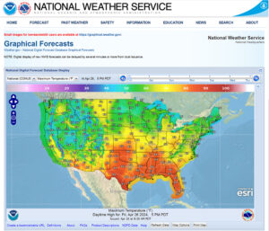
A new alternative to weather station ET is forecast reference ET or FRET (Figure 1). The National Weather Service offers FRET data on the Graphical Forecasts page of their website. FRET is one option in the digital forecast database display, and you can zoom in to find ETo data for your field up to six days in the future. In other words, FRET will assist growers to have forecast ETo up to the next six days and more effectively schedule irrigation. FRET is currently available at https://digital.weather.gov/. This tool is particularly useful to forecast crop water needs and schedule running hours of an irrigation system ahead of heat waves in avocado orchards.
IrriSAT Irrigation Decision Support System
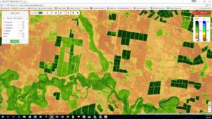
IrriSAT is a weather-based irrigation management and benchmarking technology that uses remote sensing to provide site-specific crop water management information across large spatial scales (Figure 2). It uses satellite imagery to estimate crop coefficients (Kc) at a 30-meter resolution. IrriSAT calculates Kc from a linear relationship with satellite derived Normalized Difference Vegetation Index (NDVI). Daily crop water use is determined by simply multiplying Kc and ETo observations from a nearby weather station. A beta version of the app is currently available at https://irrisat-cloud.appspot.com/, developed using Google App Engine.
OpenET
OpenET is a new online platform that uses satellites for mapping evapotranspiration (actual ET) at the scale of individual fields and currently can be used in 17 western states (Figure 3). OpenET is produced at a spatial resolution of 30m x 30m (0.22 acres). Daily, monthly and cumulative ET data are accessible on the OpenET Data Explorer. OpenET is currently available at https://openetdata.org/.
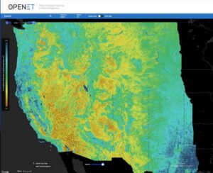
OpenET includes six models that are developed based on full or simplified implementations of the surface energy balance (SEB) approach or relies on surface reflectance data and crop type information to compute ET as a function of canopy density using a crop coefficient approach for agricultural lands. The model acronyms are eeMETRIC, geeSEBAL, DisALEXI, SSEBop, PT-JPL and SIMS. In addition, OpenET provides the OpenET ensemble values calculated from an ensemble of these six models.
OpenET Tool to Estimate Crop Water Needs of Avocado Orchards
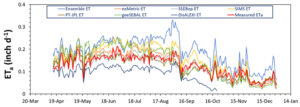
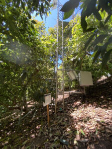
A case study was conducted to estimate daily ET values in an avocado orchard in San Diego County over a nine-month period (April 15, 2022 through Dec. 29, 2022). The ET estimated from the OpenET models and the OpenET Ensemble was evaluated versus the actual ET measured using the residual of energy balance approach with a combination of surface renewal and eddy covariance equipment (Figure 4).
The actual daily ET (measured) ranged between 0.03- and 0.23-inch d−1 over the study period (Figure 5). The cumulative ET and average daily ET were 33.2 and 0.13-inch, respectively (Table 1). Comparing the cumulative ET and average daily ET values estimated from the OpenET models and measured from the eddy covariance equipment indicated the OpenET Ensemble provided an accurate estimation of ET for this experimental site over the study period (nearly 5% overestimates of the cumulative ET); however, this is not a true finding for some other avocado sites.
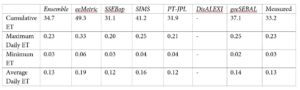
The geeSEBAL, SSEBop, PT-JPL and SIMS models showed a greater accuracy than the OpenET Ensemble on ET estimates of some other avocado sites.
While more comprehensive efforts are required to evaluate the accuracy of OpenET models under different canopy features, row orientations and environmental conditions for avocados, this case study demonstrated a good agreement between the results of the OpenET Ensemble and field measurements for an avocado site.
As a user-friendly, free, satellite-based irrigation tool, it is recommended growers consider using OpenET to manage irrigation water and fertilizer more efficiently. Further analysis and evaluation to adopt OpenET in avocado orchards under various conditions will be developed and shared soon.